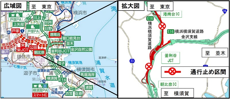
[E16] Yokohama Yokosuka Road Konandai IC-Asahina IC
Notice of nighttime closure due to bridge erection work
-We will carry out collective erection work for bridges using multi-axis bogies-
- Corporate Top
- Press Room
- Press Release Kanto Regional Head Office
- [E16] Notice of nighttime closure due to bridge construction between Konandai IC and Asahina IC Yokohama Yokosuka Road
The latest regulatory information isDraTraPlease see.
June 17, 4th year of Reiwa
East Nippon Expressway Co., Ltd.
Yokohama construction office
NEXCO EAST Yokohama Construction Office (Yokohama City, Kanagawa Prefecture) E16 To carry out the collective construction of a ramp bridge that intersects the Yokohama Yokosuka Road between the Yokohama Yokosuka Road Konandai Interchange (hereinafter referred to as "IC") and the Asahina IC along with the Yokohama Circular South Line construction project. , Yokohama Yokosuka Road will be closed at night.
We apologize for the inconvenience caused to our customers, but we ask for your understanding and cooperation so that you will have time to spare when you go out.
1. Closed section and date and time
- Closed section
Yokohama Yokosuka Road Konandai IC-Asahina IC up and down line- From the Kanazawa branch line, you can drive in the direction of Konandai and Asahina as usual.
- Closed date and timeImplementation date:Wednesday, July 27, 4th year of Reiwa21:00 pm-5 pm the next morningPreparation day:July 28th (Thursday), August 1st (Monday), 4th year of Reiwa21:00 pm-5 pm the next morning
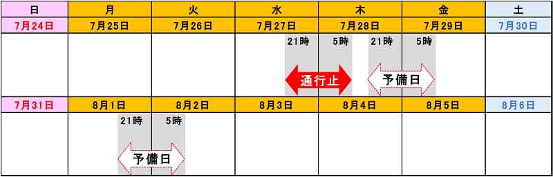

- In stormy weather, it will be postponed to the spare day.
- Construction decision will be announced on Twitter, etc. around 17:00 in the evening.
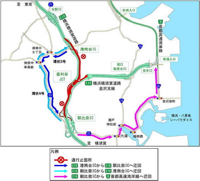
2. Detour
Please refer to the figure below for detours.
[When heading from Konandai IC to Yokosuka Road (toward Yokosuka) Asahina IC]
As shown by the
blue arrow, please use Ring No. 3 and Prefectural Road No. 23.
If you detour the Konandai IC ⇒ Asahina IC as shown in the figure below, it will take about 14 minutes (usually about 5 minutes).
[When heading from Asahina IC to Konandai IC on Yokosuka Road (toward Tokyo)]
As shown by the
light blue arrow, please use Prefectural Road No. 23 and Ring No. 3.
If you detour the Asahina IC ⇒ Konandai IC as shown in the figure below, it will take about 14 minutes (usually about 5 minutes).
[When heading from Asahina IC to Sachiura entrance on the Metropolitan Expressway Bayshore Line]
As shown by the
pink arrow, please use Prefectural Route 23, National Route 16 and National Route 357.
If you detour the Asahina IC ⇒ Yukiura entrance as shown in the figure below, it will take about 20 minutes (usually about 7 minutes).
3. Regarding transit adjustments due to suspension of traffic
For customers who temporarily flow out of the Expressway due to traffic closure, bypass the closed section, re-inflow and transfer in the forward direction, we will implement "transfer adjustment" to adjust the toll according to the section used. increase. (See Attachment-1 [PDF: 171KB], Attachment-2 [PDF: 137KB])
Transfer designated IC
| Closed place | Outflow designation IC | Re-inflow designated IC |
|---|---|---|
| [Yokosuka Road In-bound Line] Asahina IC ⇒ Konandai IC |
[Yokosuka Road] Asahina IC, Zushi IC |
[Yokosuka Road] Konandai IC, Hino IC, Bessho IC * |
| [Yokosuka Road Out-bound Line] Konandai IC ⇒ Asahina IC |
[Yokosuka Road] Konandai IC, Hino IC |
[Yokosuka Road] Asahina IC, Zushi IC, Yokosuka IC |
- ・ ・ ・ Bessho IC cannot use large cars, oversized cars, and minibuses with 11 or more people.
How to use transit adjustment
<< ETC customers >>
- Customers using ETC are requested to run the outflow designated IC wirelessly and the re-inflow designated IC wirelessly. (No transit certificate will be issued for ETC vehicles)
- ETC time zone discount will be applied, considering the transited journey as one.
Toll charges are adjusted at the time of billing, so they may differ from those displayed at the toll gate. - Insert the same ETC card for all journeys and pass through the ETC lane at the tollgate.
<< Customers for cash, etc. >>
- Customers who pay by cash, etc. should receive the "passage certificate" at the outflow designated IC, and then get the "passport" at the re-inflow designated IC, and then make the "transfer" at the toll booth that pays the fare first. Please give us your "certificate" and "passport".
《Common to customers such as ETC and cash》
- If the suspension of traffic is released after the outflow designated IC is released, the fare will be adjusted even if it is re-introduced from the IC (including the outflow designated IC) in the closed road section in the forward direction.
Four. Construction overview
With the construction of the Yokohama Circular South Line, we will carry out collective erection work for the ramp bridge that intersects the Yokohama Yokosuka Road. Since the work of collective erection is carried out using a multi-axis trolley on the main line of Yokohama Yokosuka Road, it is necessary to implement a road closure. We will close traffic on weekday nights when traffic is light so as not to cause any inconvenience to our customers. We appreciate your understanding and cooperation.
[Batch erection work]
![Image of [Batch erection work]](/pressroom/cms_assets/pressroom/2022/06/17a/04.jpg)
[Batch erection part (yellow part)]
![Image image of [Batch erection part (yellow part)]](/pressroom/cms_assets/pressroom/2022/06/17a/05.jpg)
Five. How to obtain traffic information
(1) Guidance by distribution / posting
- Notice signs, posters and leaflets will be posted at toll booths and rest facilities nearby.
- A banner will be posted on the overpass on the Expressway.
(2) Road traffic information that can be obtained before going out
- NEXCO東日本お客さまセンター(24時間オペレーターが対応)
ナビダイヤル:0570-024-024
または:03-5308-2424 - NEXCO EAST Expressway Traffic Information Site "DraTra"Real-time information[Mobile] http://m.drivetraffic.jp/Construction regulation information
- 日本道路交通情報センター(JARTIC) 道路交通情報
全国共通ダイヤル 050-3369-6666(携帯電話短縮ダイヤル #8011)
※全国どこからでも最寄りの情報センターに接続します。
全国・関東甲信越情報 050-3369-6600
神奈川情報 050-3369-6614
【PC】https://www.jartic.or.jp/
(3) Road traffic information available while using the Expressway
- Road information board
- Highway radio (AM1620kHz)
The highway radio section is indicated by signs on the Expressway. - Highway Information Terminal
We will inform you of road information in an easy-to-understand manner by the monitor screens installed in SA / PA. - VICS
You can get road traffic information with VICS-compatible car navigation and other on-board devices.
- Information is also distributed on the official Twitter account.
" NEXCO EAST (Kanto)" (@e_nexco_kanto) Real-time traffic information
" NEXCO EAST (Kanto construction regulations)" (@e_nexco_kanto_k) Judgment regarding implementation of construction regulations

To view the PDF file, you need the Adobe Systems plug-in software "Acrobat Reader (Japanese version)". If you do not have Download from here (free)Please use it.
Related Sites and Content
If you are looking for information on fares, routes, service areas and parking areas, please click here.
If you are looking for real-time traffic congestion and restriction information, click here.
NEXCO EAST (Road Disaster Prevention Information) Official X
Click here if you are looking for road information such as road closures during disasters.