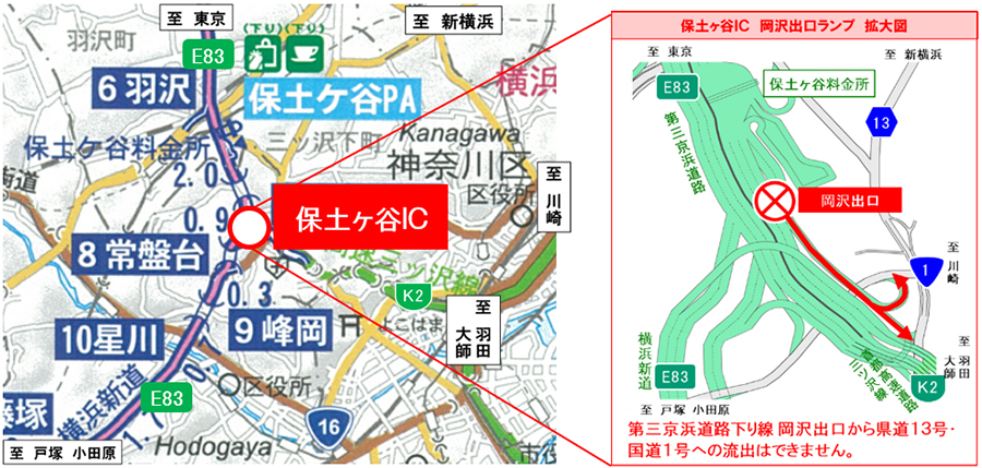
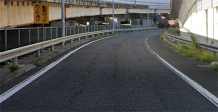
[E83] Daisan-Keihin Road Out-bound Line Hodogaya IC Okazawa Exit Ramp
Nighttime closure notice
December 1st (Mon) to 4th (Thu), 8th (Mon) to 9th (Tue) from 8pm to 5am each day
~ Repair work on damaged pavement ~
- Corporate Top
- Press Room
- Press Release Kanto Regional Head Office
- [E83] Daisan Daisan-Keihin Road Out-bound Line Hodogaya IC Okazawa Exit Lamp Notice of Night Closure
The latest regulatory information isDraTraPlease see.
November 17, 2020
East Nippon Expressway Co., Ltd.
Keihin Management Office
NEXCO EAST Keihin Management Office (Yokohama, Kanagawa Prefecture) will be closing the Okazawa exit ramp at the Hodogaya Interchange (hereinafter referred to as the "IC") on Out-bound lane of the E83 Daisan-Keihin Road (hereinafter referred to as the "Third Keihin") at night to carry out pavement repair work.
We apologize for any inconvenience this may cause, and we ask for your understanding and cooperation in allowing yourself plenty of time when going out.
1. Closed location and date and time
- Closures:
Third Keihin Line Out-bound) Hodogaya IC Okazawa Exit Ramp - Attached to each line E83 The indications such as indicate the route number (numbering) of Expressway.
- Date and timeImplementation date:December 1st (Monday) to December 4th (Thursday), December 8th (Monday) to December 9th (Tuesday), 2020Every night from 20:00 to 5:00 the next morningPreparation day:December 5th (Friday), 10th (Wednesday) to 11th (Thursday), 2020Every night from 20:00 to 5:00 the next morning
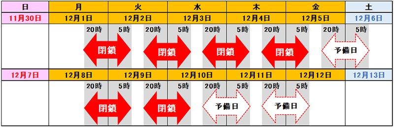

- In stormy weather, it will be postponed to the spare day.
- If the work is postponed due to bad weather between December 1st (Monday) and 4th (Thursday), the work will be carried out on the backup day, December 5th (Friday).
- The decision to carry out construction will be announced on X (formerly Twitter) etc. around 5:00 pm on the day of construction.
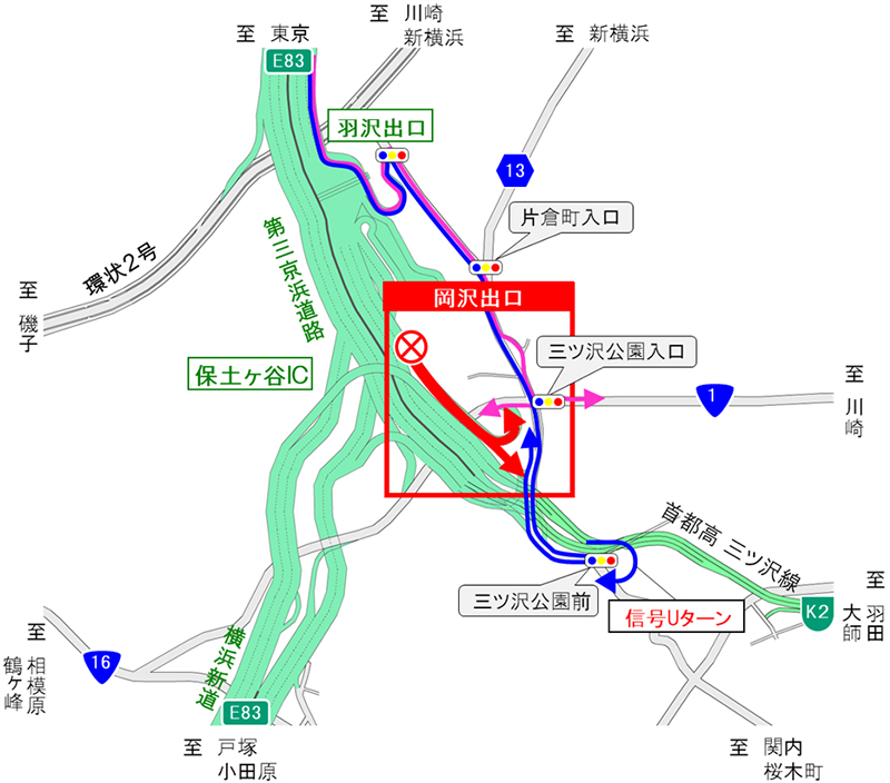
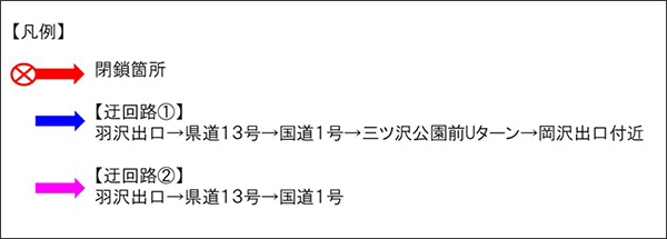
2. Detour
Please refer to the diagram below for the detour route.
The detour will increase the travel time, so please allow plenty of time for your trip.
- If you are heading towards the Okazawa Exit
As indicated by the blue arrow, please take the Daisan Keihin Hazawa Exit. Proceed along Prefectural Route 13 towards Kannai and Sakuragicho, then make a U-turn at the traffic light in front of Mitsuzawa Park. The estimated travel time is approximately 9 minutes (usually 3 minutes). - When heading to Prefectural Road 13 / National Road 1
Please use the Daisan Keihin Hazawa exit as shown by the pink arrow. It will take about 7 minutes (usually about 3 minutes).
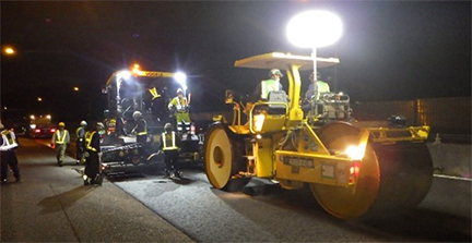
3. Construction overview
Due to damage to the pavement at the Okazawa exit ramp of Hodogaya IC on the Third Keihin Line Out-bound), pavement repair work will be carried out.
The section where this work will be carried out is one lane, and as normal lane restrictions will not allow for the work to be carried out, it will be necessary to close the ramps to carry out the work. Therefore, in order to minimize inconvenience to customers, the ramps will be closed at night on weekdays when traffic volume is low, and the work will be carried out in a concentrated and efficient manner. This work is necessary to ensure safe and comfortable use of Expressway, so we ask for your understanding and cooperation.


Four. How to obtain traffic information
(1) Guidance by distribution / posting
- Notice signs, posters and leaflets will be posted at toll booths and rest facilities nearby.
(2) Road traffic information that can be obtained before going out
- NEXCO東日本お客さまセンター(24時間オペレーターが対応)
ナビダイヤル:0570-024-024
または:03-5308-2424 - NEXCO EAST Expressway Traffic Information Site "DraTra"Real-time information[Mobile] http://m.drivetraffic.jp/Construction regulation information
- 日本道路交通情報センター(JARTIC)道路交通情報
全国共通ダイヤル 050-3369-6666
(携帯電話短縮ダイヤル #8011)
※全国どこからでも最寄りの情報センターに接続します。
全国・関東甲信越情報 050-3369-6600
神奈川情報 050-3369-6614
【PC】https://www.jartic.or.jp/
(3) Road traffic information available while using the Expressway
- Road information board
- Highway radio (AM1620kHz)
The highway radio section is indicated by signs on the Expressway. - VICS
You can get road traffic information with VICS-compatible car navigation and other on-board devices.
- Information is also distributed on official X (formerly Twitter) and LINE accounts.
[X (old Twitter)]
"NEXCO EAST (Kanto)" (@e_nexco_kanto) Real-time traffic information
“NEXCO EAST (Kanto Construction Regulations)” (@e_nexco_kanto_k) Decision to implement construction regulations
[LINE]
"NEXCO EAST" (@e-nexco) Road closures and weather information

To view the PDF file, you need the Adobe Systems plug-in software "Acrobat Reader (Japanese version)". If you do not have Download from here (free)Please use it.
Related Sites and Content
If you are looking for information on fares, routes, service areas and parking areas, please click here.
If you are looking for real-time traffic congestion and restriction information, click here.
NEXCO EAST (Road Disaster Prevention Information) Official X
Click here if you are looking for road information such as road closures during disasters.