Expressway traffic conditions during the Obon period (breaking news)
[Niigata version]
~ Friday, August 6th, 3rd year of Reiwa ~ Monday, August 16th, 11 days ~
- Corporate Top
- Press Room
- Press Release Niigata office
- Expressway traffic conditions during the Obon festival (breaking news) [Niigata Prefecture version]
August 17, 3rd year of Reiwa
East Nippon Expressway Co., Ltd.
Niigata Regional Head Office
NEXCO EAST Niigata Regional Head Office (Chuo-ku, Niigata City) has summarized the traffic conditions during the Obon period [11 days from August 6th (Friday) to August 16th (Monday), 3rd year of Reiwa].
≪Overview of traffic conditions≫
- The average daily traffic volume on the representative section decreased to 51% compared to the year before last.
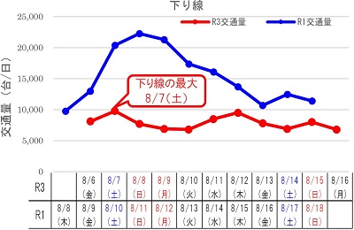
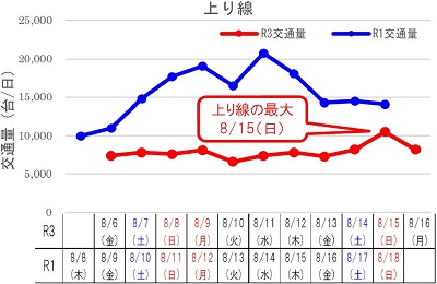
- The traffic volume during the period reached its maximum on Saturday, August 7th on Out-bound line and Sunday, August 15th on the In-bound
- The number of traffic jams over 5km was 0, a decrease of 5 times compared to the previous year.
1. 1. Average daily traffic volume for representative sections during the Obon period * 1 (vehicles / day)
| Road name | section | Reiwa 3 years A |
Reiwa First year B |
Compared to the year before last A / B |
Reiwa 2 years C |
Reiwa 2 years ratio A / C |
|---|---|---|---|---|---|---|
| E8Hokuriku Expressway | Asahi IC-Clairless IC | 14,000 | 26,400 | 53% | 13,800 | 101% |
| E17Kan-Etsu Expressway | Minakami IC to Yuzawa IC | 17,700 | 35,300 | 50% | 18,100 | 98% |
| Daily traffic volume based on simple average of the above 2 sections | 15,900 | 30,900 | 51% | 16,000 | 99% | |
"IC: Interchange"
- Traffic volume is approximate by traffic counter (all models)
≪Reference: Comparison period≫
Reiwa 3 years, 2020, 2019 Obon period day arrangement
| R3 years | 8/6 (Money) |
8/7 (soil) |
8/8 (Day) |
8/9 (Month) |
8/10 (fire) |
8/11 (water) |
8/12 (wood) |
8/13 (Money) |
8/14 (soil) |
8/15 (Day) |
8/16 (Month) |
|
|---|---|---|---|---|---|---|---|---|---|---|---|---|
| R2 year | 8/7 (Money) |
8/8 (soil) |
8/9 (Day) |
8/10 (Month) |
8/11 (fire) |
8/12 (water) |
8/13 (wood) |
8/14 (Money) |
8/15 (soil) |
8/16 (Day) |
||
| R first year | 8/8 (wood) |
8/9 (Money) |
8/10 (soil) |
8/11 (Day) |
8/12 (Month) |
8/13 (fire) |
8/14 (water) |
8/15 (wood) |
8/16 (Money) |
8/17 (soil) |
8/18 (Day) |
2. Main congestion points
Reiwa 3 years Congestion situation during the Obon period (maximum congestion length 5 km or more): 0 times in total
≪Reference≫
2019 (maximum congestion length 5km or more): A total of 5 occurrences
| worst | Road name / direction | Traffic jam location | Peak date and time | Congestion length | Congestion factors |
|---|---|---|---|---|---|
| 1 | E8Hokuriku Expressway (below) | Nakanoshima Mitsuke IC-Sanjo Tsubame IC | 8/11 (Sun) around 10:50 | 8.5km | Accident and traffic concentration |
| 2 | E18 Joshin-Etsu Expressway (below) | Toyota Iyama IC-Myoko Kogen IC | 8/11 (Sun) around 7:10 | 7.9km | Traffic concentration |
| 3 | E8Hokuriku Expressway (below) | Sanjo Tsubame IC-Niigata Nishi IC | 8/12 (Monday) around 11:15 | 6.6km | Accident and traffic concentration |
| 4 | E8 Hokuriku Expressway (above) | Sanjo-Tsubame IC-Nakanoshima Mitsuke IC | 8/14 (Wednesday) around 11:15 | 6.3km | Traffic concentration |
| 5 | E8 Hokuriku Expressway (above) | Niigata Nishi IC-Sanjo-Tsubame IC | 8/8 (Thursday) around 17:30 | 5.2km | Broken car and traffic concentration |
- There is no record of traffic congestion of 5 km or more during the Obon period of 2020
3. 3. Average daily traffic volume of representative sections (average of 2 sections)

To view the PDF file, you need the Adobe Systems plug-in software "Acrobat Reader (Japanese version)". If you do not have Download from here (free)Please use it.
Related Sites and Content
If you are looking for information on fares, routes, service areas and parking areas, please click here.
If you are looking for real-time traffic congestion and restriction information, click here.
NEXCO EAST (Road Disaster Prevention Information) Official X
Click here if you are looking for road information such as road closures during disasters.