(7th report)
About the situation of the Expressway with the earthquake centering on the Hamadori district in Fukushima Prefecture
- Corporate Top
- Press Room
- Press Release Tohoku office
- (7th report) About the situation of Expressway following the earthquake with the epicenter of Fukushima Prefecture Hamadori district
April 12, 2011
As of 14:20
East Nippon Expressway Co., Ltd.
Tohoku Regional Head Office
At NEXCO East Japan Tohoku Regional Head Office (Aoba Ward, Sendai City), earthquakes occurred at 17:16 on April 11, 2011 and at 14:07 on April 12, 2011, with the epicenter in the Hamadori region of Fukushima Prefecture. In response to this, we closed the lines and sections where there was a lot of shaking, carried out an emergency inspection, and released the road closures sequentially from the sections where safety was confirmed.
1. Closed section (in Tohoku Regional Head Office Office)
| Road name | section | By vertical line | Remarks |
| Ban-Etsu Expressway | Iwaki JCT-Ono IC | Up and down | |
| Joban Expressway | Iwaki Nakoso IC-Iwaki Shikura IC | Up and down | |
| Joban Expressway | Iwaki Shikura IC-Joban Tomioka IC | Up and down | Because of the evacuation area of the nuclear power plant, traffic will be closed from March 11. |
- The latest information is DraTra, Information including general national highways JARTIC Please check with.
2. Major damages currently confirmed (Tohoku Regional Head Office Office)
| Road name | section | By vertical line | Damage situation |
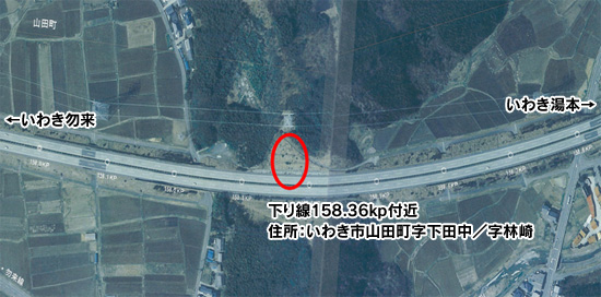
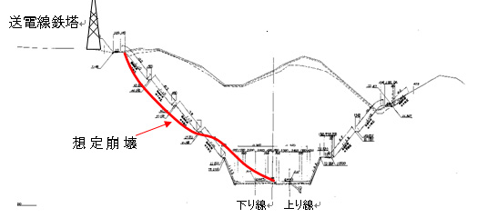
| Joban Expressway | Iwaki Nakoso IC-Iwaki Yumoto IC | Up and down | Out-bound slope cut slope reaches In-bound line |
3. Current work status
We started to carry out the crushed rock mass into small pieces.
[Location map, etc.]
[Collapse situation photo]
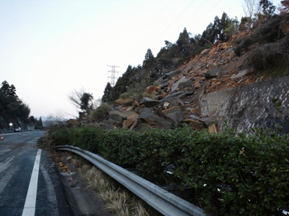
The situation where the collapsed rock block covers the entire Out-bound line
(From the In-bound line, take Iwaki Yumoto behind and head towards Iwaki Nakoso in the early morning of April 12)
[Approximate collapse]
Extension: (Road direction): About 50m
Width: (road sideways): About 15m
Road deposit height: About 8m
Height of slope collapse: approx. 35 m
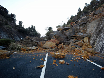
The situation where the collapsed rock block covers the entire Out-bound line
(From the Out-bound line, take Iwaki Yumoto behind and head towards Iwaki Nakoso in the early morning of April 12)
[Work status photo]
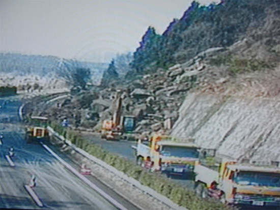
Carrying out work situation from the bottom end of the rock in sequence (from the In-bound line,
Iwaki Yumoto behind and headed towards Iwaki Nakoso at around 8:30 on April 12
【Document】NEXCO EAST /Tohoku Regional Head Office Expressway etc. [PDF: 154KB]

To view the PDF file, you need the Adobe Systems plug-in software "Acrobat Reader (Japanese version)". If you do not have Download from here (free)Please use it.
関連サイト・コンテンツ
料金・ルート検索、サービスエリア・パーキングエリアの情報をお探しの方はこちら。
リアルタイムの渋滞・規制情報をお探しの方はこちら。
災害時の通行止めなどの道路情報をお探しの方はこちら。