【E17】関越道 大泉IC夜間ランプ(新潟方面)閉鎖のお知らせ
6月12日(月)~14日(水) 各日夜19時から翌朝5時まで
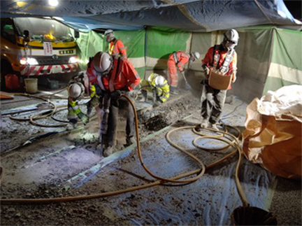
~橋りょうの補修工事を行います~
最新の規制情報は、ドラとらをご覧下さい。
令和5年6月5日
東日本高速道路株式会社
所沢管理事務所
NEXCO東日本 所沢管理事務所(埼玉県所沢市)では、E17関越自動車道(以下「関越道」)大泉インターチェンジ(以下「IC」)にて、伸縮装置取替工事を行うため、ランプ閉鎖を実施します。
お客さまには大変ご迷惑をおかけしますが、お出かけの際には時間にゆとりを持っていただきますよう、ご理解とご協力をお願いいたします。
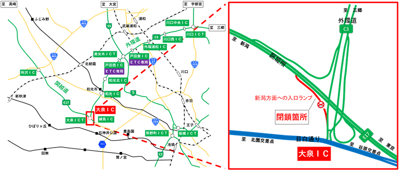
1.閉鎖箇所及び日時
- 閉鎖箇所:
関越道 大泉IC 新潟方面への入口ランプ - 各路線に付しているE17等の表示は、高速道路等の路線番号(ナンバリング)を示しています。
- 日時
実施日:令和5年6月12日(月)~14日(水)各日夜19時~翌朝5時予備日:令和5年6月15日(木)、16日(金)、19日(月)~22日(木)各日夜19時~翌朝5時
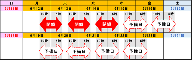

- 荒天時は、予備日に順延します。
順延する場合の予備日や迂回路等については、別途資料をご覧ください。 - 工事実施判断は、当日の17時頃にTwitterなどでお知らせします。
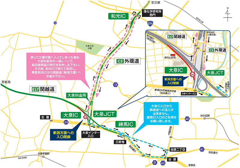
2.迂回路
迂回路は、下図をご参照ください。
- 関越道 練馬ICへの迂回路は水色矢印の通り、大泉IC出口(東京方面) ⇒ 目白通り ⇒ 谷原左折 ⇒ 笹目通り ⇒ 谷原二丁目左折 ⇒ 北原通り ⇒ 三軒寺 ⇒ 目白通り ⇒ 練馬ICから関越道をご利用ください。
下図のとおり迂回した場合、迂回の所要時間は約7分(約3.5km)かかる見込みです。
誤って外環道 三郷方面へ入ってしまった場合は、ピンク色矢印の通り、和光ICで一旦降りて反転し、再度、和光ICから関越道(新潟方面)へ、お進み下さい。
3.工事概要
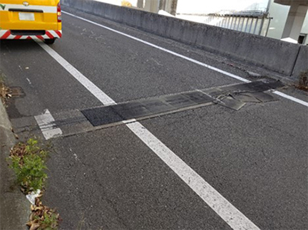
関越道 大泉ICにおいて、橋と橋の繋ぎ目に設置されている伸縮装置が経年劣化により損傷しているため、より耐久性の高い鋼製の伸縮装置への取替工事を実施します。
この工事を行う区間は1車線であり、工事実施にあたって通常の車線規制では施工が出来ないことから、ランプを閉鎖して作業を行います。
そのため、お客さまへ極力ご迷惑をおかけしないよう、ランプの閉鎖は交通量が少ない夜間に行い、工事を集中的かつ効率的に実施します。
安全・快適に高速道路をご利用いただくために必要な工事ですので、ご理解とご協力をお願いします。


4.交通情報の入手方法について
(1)配布・掲示物によるご案内
- 予告看板やポスター・リーフレットを、周辺の料金所・休憩施設に掲示します。
- 横断幕を高速道路上の跨道橋、及び一般道の歩道橋などに掲示します。
- ランプ閉鎖当日は、迂回路看板を迂回路の主要交差点に設置します。
(2)お出かけ前に入手できる道路交通情報
- NEXCO東日本お客さまセンター(24時間オペレーターが対応)
ナビダイヤル:0570-024-024
または:03-5308-2424 - NEXCO東日本 道路交通情報サイト「ドラとら」
リアルタイム情報【携帯】http://m.drivetraffic.jp/
- 日本道路交通情報センター(JARTIC) 道路交通情報
全国共通ダイヤル 050-3369-6666
(携帯短縮ダイヤル #8011)
※全国どこからでも最寄りの情報センターに接続します。
全国・関東甲信越情報 050-3369-6600
都内情報 050-3369-6613
埼玉情報 050-3369-6611
【PC】https://www.jartic.or.jp/
(3)高速道路をご利用中に入手できる道路交通情報
- 道路情報板
- ハイウェイラジオ(AM1620kHz)
ハイウェイラジオを放送している区間は、高速道路上の標識によりご案内しております。 - ハイウェイ情報ターミナル
SA・PAに設置されているモニター画面などにより、道路情報を分かりやすくお知らせします。 - VICS
VICS対応のカーナビゲーション等の搭載機で、道路交通情報が入手できます。
- Twitter・LINEの公式アカウントでも情報を配信しています。
【Twitter】
「NEXCO東日本(関東)」
(@e_nexco_kanto) リアルタイムの交通情報
「NEXCO東日本(関東工事規制)」
(@e_nexco_kanto_k) 工事規制の実施判断
【LINE】
「NEXCO東日本」(@e-nexco) 通行止めや気象情報

PDFファイルをご覧いただくには、AdobeSystems社のプラグインソフト「Acrobat Reader(日本語版)」が必要です。お持ちでない方は、こちらからダウンロード(無料)してご利用ください。
関連サイト・コンテンツ
料金・ルート検索、サービスエリア・パーキングエリアの情報をお探しの方はこちら。
リアルタイムの渋滞・規制情報をお探しの方はこちら。
災害時の通行止めなどの道路情報をお探しの方はこちら。