台風19号に伴う上信越自動車道(碓氷軽井沢IC~佐久IC)の 盛土変状に係る緊急対策について(第2報)
令和元年10月15日
東日本高速道路株式会社
関東支社
台風19号の影響に伴い、通行止めを継続している上信越自動車道 碓氷軽井沢IC~佐久IC間において、盛土変状が継続しているため、緊急対策工事を実施します。
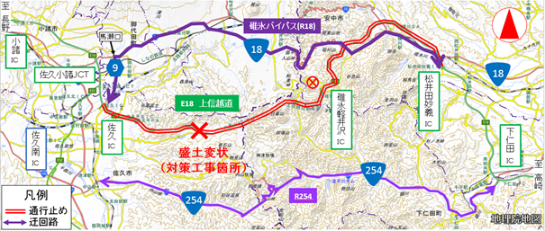
緊急対策工事が完了するまで通行止めを継続します。お客さまにおかれましては、以下の迂回路をご利用いただきますようお願いします。
引き続き、お客さまにはご不便をおかけしますが、ご理解・ご協力をお願いします。
※碓氷軽井沢ICと国道18号を結ぶアクセス道路が現在通行できないため、通行止め区間は松井田妙義IC~佐久IC間としております。
1 災害の概要
別紙【PDF:545KB】のとおり、上信越自動車道の佐久市香坂地区の盛土に変状が確認されました。地下水位が上昇し、変状が進行していることから、緊急対策工事を行います。
2 位置図及び迂回路
通行止め中は、国道18号(碓氷バイパス)を迂回路としてご利用ください。また、国道254号と下仁田ICを利用した迂回も可能です。
工事に支障となりますので、緊急車両などにおかれましても迂回路のご利用にご協力願います。
なお、通行止めにより高速道路を一旦流出し、通行止め区間を迂回して、再度同一方向に乗り継がれるお客さまは、ご利用区間に応じて通行料金の調整を行います。
3 通行止め解除の見通し
通行止め解除までには少なくとも10日程度を要する見込みです。
※通行止め解除後は、対面通行(上下各1車線)を予定しています。
最新の交通状況
- 道路交通情報NOW!!―日本道路交通情報センター
- ドライブトラフィック(PC・スマホ)
- ドライブトラフィック(携帯)
- NEXCO東日本(道路防災情報)公式ツイッター
- NEXCO東日本(東北)公式ツイッター
- NEXCO東日本(関東)公式ツイッター
- 走行中に入手できる道路交通情報
・道路情報板
・ハイウェイラジオ(AM1620kHz)
放送している区間は、高速道路上の標識によりご案内しています。
・ハイウェイ情報ターミナル
SA・PAに設置されているモニター画面などにより、広域の道路交通情報をお知らせしています。

PDFファイルをご覧いただくには、AdobeSystems社のプラグインソフト「Acrobat Reader(日本語版)」が必要です。お持ちでない方は、こちらからダウンロード(無料)してご利用ください。
関連サイト・コンテンツ
料金・ルート検索、サービスエリア・パーキングエリアの情報をお探しの方はこちら。
リアルタイムの渋滞・規制情報をお探しの方はこちら。
災害時の通行止めなどの道路情報をお探しの方はこちら。