【C3】外環道 夜間通行止め及びJCT・IC夜間ランプ閉鎖のお知らせ
~標識板取替工事等を行います~
最新の規制情報は、ドラとらをご覧下さい。
令和2年10月16日
東日本高速道路株式会社
三郷管理事務所
NEXCO東日本 三郷管理事務所(埼玉県三郷市)では、C3東京外環自動車道(以下「外環道」)内回り 三郷中央IC(みさとちゅうおう)から草加ICにて標識板の取替工事、橋梁補修工事を行うため、夜間通行止め及びJCT・ICの夜間ランプ閉鎖を実施します。
お客さまには大変ご迷惑をおかけしますが、お出かけの際には時間にゆとりを持っていただきますよう、ご理解とご協力をお願いします。
1.通行止め・閉鎖箇所及び日時
(1)通行止め・閉鎖箇所
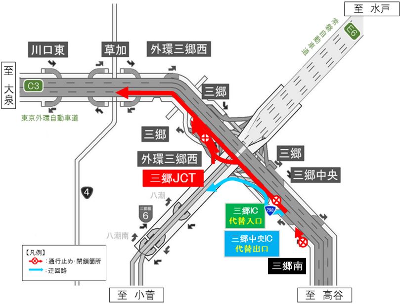
①外環道 内回り 外環三郷西IC 入口ランプ
②外環道 内回り 三郷中央IC⇒草加IC
③常磐道 上り及び首都高 三郷線から外環道内回りへ流入する三郷JCTのランプ
④外環道 内回り 三郷南IC 入口ランプ
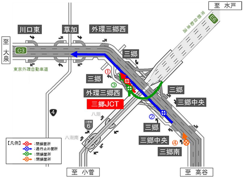
- 各路線に付しているC3等の表示は、高速道路等の路線番号(ナンバリング)を示しています。
(2)日時
実施日:令和2年11月16日(月)
① 夜20時~翌朝5時
②③④ 夜23時~翌朝4時
予備日:令和2年11月17日(火)~19日(木)
① 各日夜20時~翌朝5時
②③④ 各日夜23時~翌朝4時
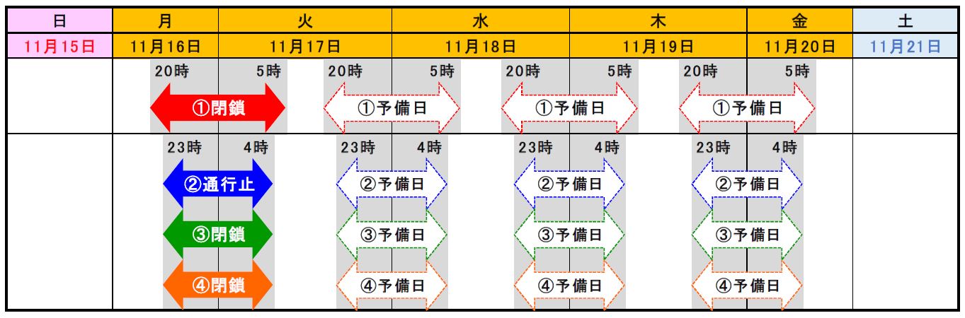

- 荒天時は、予備日に順延します。
- 工事実施判断は、当日の17時頃にTwitterなどでお知らせします。
2.迂回路
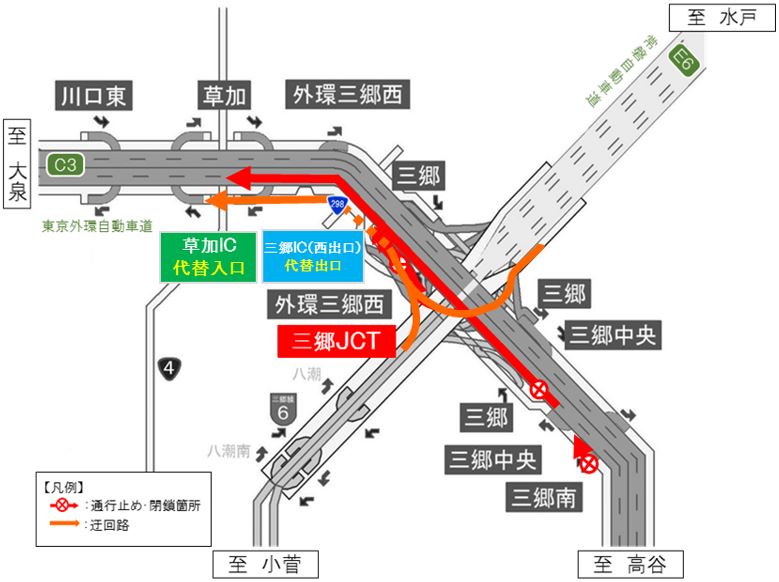
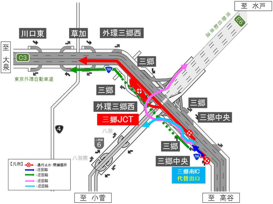
①外環道(内回り)高谷方面から大泉方面へ向かう場合[外環三郷西IC→草加ICの迂回路]
紫色矢印のとおり、外環道(内回り)外環三郷西ICから、国道298号を大泉方面に進み、草加ICをご利用ください。
外環三郷西ICから草加ICを迂回した場合、所要時間は約8分(通常約6分)かかる見込みです。
![①外環道(内回り)高谷方面から大泉方面へ向かう場合[外環三郷西IC→草加ICの迂回路]のイメージ画像](/pressroom/cms_assets/pressroom/2020/10/16/03.jpg)
②外環道(内回り)高谷方面から大泉方面へ向かう場合[三郷中央IC→草加ICの迂回路]
緑色矢印のとおり、外環道(内回り)三郷中央ICから流出し、国道298号を大泉方面に進み、草加ICをご利用ください。
三郷中央ICから草加ICを迂回した場合、所要時間は約14分(通常約7分)かかる見込みです。
![②外環道(内回り)高谷方面から大泉方面へ向かう場合[三郷中央IC→草加ICの迂回路]のイメージ画像](/pressroom/cms_assets/pressroom/2020/10/16/04.jpg)
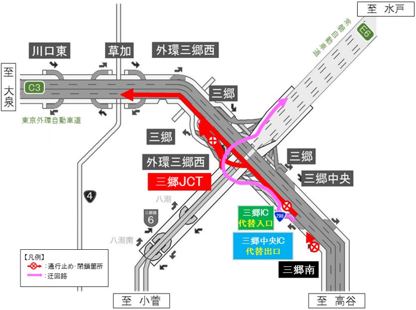
③常磐道(上り)水戸方面及び首都高 三郷線 小菅方面から外環道(内回り)大泉方面へ向かう場合
オレンジ色矢印のとおり、常磐道(上り)及び首都高 三郷線から三郷JCTを大泉方面へ進み、外環道(内回り)三郷IC(西出口)から流出、国道298号へ合流後、草加方面へ進み、草加ICをご利用ください。
三郷IC(西出口)から草加ICを迂回した場合、所要時間は約11分(通常約6分)かかる見込みです。
④外環道(内回り)高谷方面から常磐道(下り)水戸方面へ向かう場合
桃色矢印のとおり、外環道(内回り)三郷中央ICから流出し、国道298号を草加方面に進み、三郷ICをご利用いただき、分岐を常磐道(下り)水戸方面に進み、常磐道をご利用ください。
三郷中央ICから三郷ICを迂回した場合、所要時間は約4分(通常約3分)かかる見込みです。
⑤外環道(内回り)高谷方面から首都高 三郷線 小菅方面へ向かう場合
水色矢印のとおり、外環道(内回り)三郷中央ICから流出し、国道298号を草加方面へ進み、三郷ICをご利用いただき、分岐を首都高 三郷線 小菅方面へ進み、首都高をご利用ください。
三郷中央ICから三郷ICを迂回した場合、所要時間は約2分(通常約1分)かかる見込みです。
⑥三郷南IC入口ランプを利用せずに外環道(内回り)大泉方面、常磐道(下り)水戸方面、首都高 三郷線 小菅方面へ向かう場合
青色矢印のとおり、国道298号を三郷方面に進み、大泉方面は緑色矢印のとおり草加ICから再流入し、外環道(内回り)を、常磐道(下り)水戸方面は桃色矢印のとおり三郷ICから再流入し、常磐道(下り)を、首都高 三郷線 小菅方面は水色矢印のとおり三郷ICから再流入し、首都高 三郷線を、それぞれご利用ください。
三郷南ICを迂回した場合、所要時間は大泉方面で約16分(通常約12分)、水戸方面、小菅方面で約9分(通常約5分)かかる見込みです。
3.乗継調整のご案内
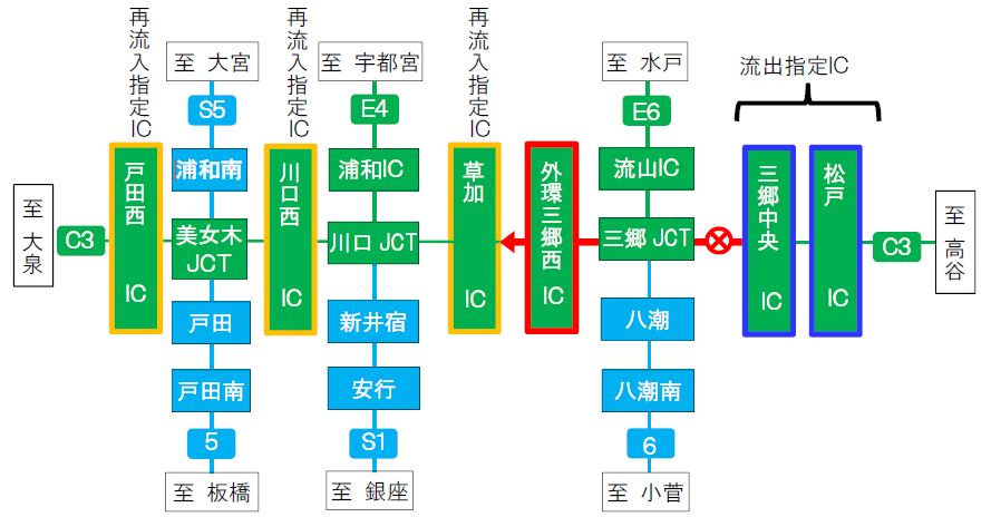
本線通行止めにより高速道路を一旦流出し、通行止め区間を迂回して、再流入して順方向に乗り継がれるお客さまには、ご利用区間に応じて通行料金を調整する「乗継調整」を実施します。
乗継指定IC
| 通行止め箇所 | 流出指定IC | 再流入指定IC |
|---|---|---|
| 【外環道(内回り)】 三郷中央IC⇒草加IC |
【外環道(内回り)】 三郷中央IC 松戸IC |
【外環道(内回り)】 草加IC 川口西IC 戸田西IC |
乗継調整のご利用方法
≪ETCのお客さま≫
- ETCをご利用のお客さまは、流出指定ICを無線走行していただき、再流入指定ICも無線走行をお願いします。
- 乗り継ぎされた走行を一つの走行とみなして、ETC時間帯割引を適用します。
なお、通行料金は請求時の調整となるため、料金所での料金表示器と異なる場合があります。 - 全行程で同一のETCカードを挿入して、料金所のETCレーンを通行してください。
≪現金等のお客さま≫
- 現金等でお支払いのお客さまは、再流入指定ICの料金所係員に通行止めによる再利用である旨お申し出ください。
≪ETC・現金等のお客さま共通≫
- 流出指定ICで流出後、通行止めが解除された場合は、順方向にある通行止め区間内のIC(流出指定ICを含む)から再流入されても料金調整を行います。
4.工事概要
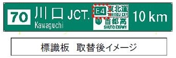
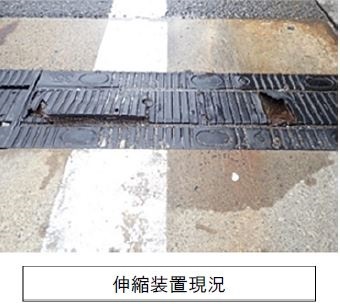
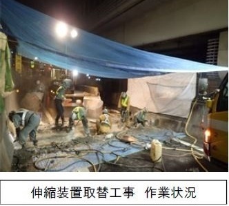
外環道において、標識板へナンバリングを行うため、標識板取替工事を実施します。また、橋梁の伸縮装置の取替工事もあわせて実施します。工事実施にあたって、通常の車線規制では施工ができないことから、本線の通行止め及びランプの閉鎖により作業を行う必要があります。そのため、お客さまへ極力ご迷惑をおかけしないよう、交通量が少ない平日の夜間に本線の通行止め及びランプの閉鎖を行い、工事を集中的かつ効率的に実施します。安全・快適に高速道路をご利用いただくために必要な工事ですので、ご理解とご協力をお願いします。
5.交通情報の入手方法について
(1)配布・掲示物によるご案内
- 予告看板やポスター・リーフレットを、周辺の料金所・休憩施設に掲示します。
- 横断幕を高速道路上の門型標識柱に掲示します。
(2)お出かけ前に入手できる道路交通情報
- NEXCO東日本お客さまセンター(24時間オペレーターが対応)
ナビダイヤル:0570-024-024
または:03-5308-2424 - NEXCO東日本 道路交通情報サイト 「ドラとら」
リアルタイム情報【携帯】http://m.drivetraffic.jp/ - 日本道路交通情報センター(JARTIC) 道路交通情報
全国共通ダイヤル 050-3369-6666(携帯電話短縮ダイヤル #8011)
※全国どこからでも最寄りの情報センターに接続します。
全国・関東甲信越情報 050-3369-6600
埼玉情報 050-3369-6611
【PC】http://www.jartic.or.jp/ - ハイウェイテレホン(5分毎に更新される最新情報を24時間提供)
岩槻局 048-758-1620
大泉局 03-3922-1620
(携帯電話・PHS短縮ダイヤル #8162)
(3)高速道路をご利用中に入手できる道路交通情報
- 道路情報板
- ハイウェイラジオ(AM1620kHz)
ハイウェイラジオを放送している区間は、高速道路上の標識によりご案内しております。 - ハイウェイ情報ターミナル
SA・PAに設置しているモニター画面などにより、道路情報を分かりやすくお知らせします。 - VICS
VICS対応のカーナビゲーションなどの搭載機で、道路交通情報が入手できます。
- Twitterの公式アカウントでも情報を配信しています。
「NEXCO東日本(関東)」(@e_nexco_kanto) リアルタイムの交通情報
「NEXCO東日本(関東工事規制)」(@e_nexco_kanto_k) 工事規制の実施判断

PDFファイルをご覧いただくには、AdobeSystems社のプラグインソフト「Acrobat Reader(日本語版)」が必要です。お持ちでない方は、こちらからダウンロード(無料)してご利用ください。
関連サイト・コンテンツ
料金・ルート検索、サービスエリア・パーキングエリアの情報をお探しの方はこちら。
リアルタイムの渋滞・規制情報をお探しの方はこちら。
災害時の通行止めなどの道路情報をお探しの方はこちら。