(10th report)
About the situation of the Expressway with the earthquake centering on the Hamadori district in Fukushima Prefecture
- Corporate Top
- Press Room
- Press Release Tohoku office
- (10th report) About the situation of Expressway following the earthquake with the epicenter of Fukushima Prefecture
April 12, 2011
As of 19:15
East Nippon Expressway Co., Ltd.
Tohoku Regional Head Office
NEXCO EAST Tohoku Regional Head Office (Aoba Ward, Sendai City) received the earthquake that occurred in the Hamadori area of Fukushima Prefecture at 17:16 on April 11, 2011 and around 19:15 on April 12, We closed roads and sections where there was a lot of sway, conducted emergency inspections, and removed the road closures from sections where safety was secured.
1. The section where the road was closed
| Road name | section | By vertical line | Remarks |
| Joban Expressway | Iwaki Yumoto IC-Iwaki Central IC | Up and down | 19:15 closed |
| Ban-Etsu Expressway | Iwaki JCT-Iwaki Sanwa IC | Up and down | 19:15 closed |
2. Closed section (Tohoku Regional Head Office Office)
| Road name | section | By vertical line | Remarks |
| Joban Expressway | Iwaki Nakoso IC-Iwaki Central IC | Up and down | |
| Joban Expressway | Iwaki JCT-Iwaki Sanwa IC | Up and down | |
| Joban Expressway | Iwaki Shikura IC-Joban Tomioka IC | Up and down | Because of the evacuation area of the nuclear power plant, traffic will be closed from March 11. |
- The latest information is DraTra, Information including general national highways JARTIC Please check with.
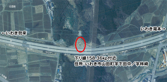
3. Major damages currently confirmed (Tohoku Regional Head Office Office)
| Road name | section | By vertical line | Damage situation |
| Joban Expressway | Iwaki Nakoso IC-Iwaki Yumoto IC | Up and down | Out-bound slope cut slope reaches In-bound line |
4. Current work status
- The collapsed rock mass is being split into small pieces and is being carried out.
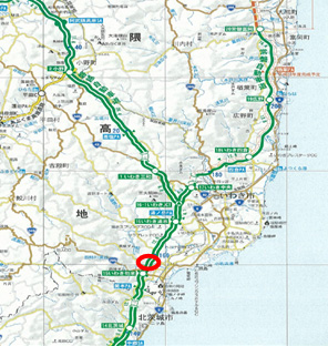
[Location map, etc.]
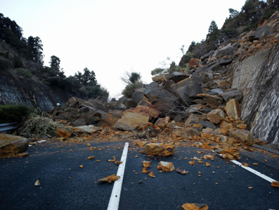
[Collapse situation photo]
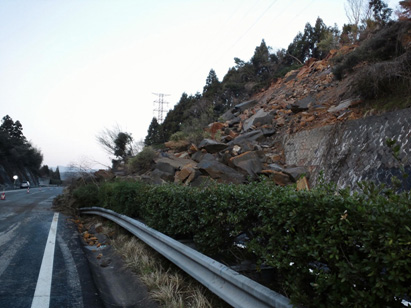
The situation where the collapsed rock block covers the entire Out-bound line
(From the In-bound line, take Iwaki Yumoto behind and head towards Iwaki Nakoso in the early morning of April 12)
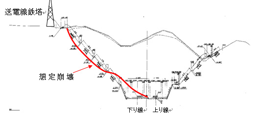
[Approximate collapse]
Extension: (Road direction): About 50m
Width: (road sideways): About 15m
Road deposit height: About 8m
Height of slope collapse: approx. 35 m
The situation where the collapsed rock block covers the entire Out-bound line
(From the Out-bound line, take Iwaki Yumoto behind and head towards Iwaki Nakoso in the early morning of April 12)
[Work status photo]
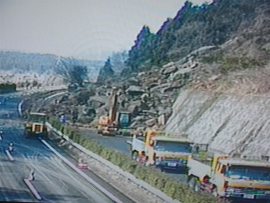
Carrying out work situation from the bottom end of the rock in sequence (from the In-bound line,
Iwaki Yumoto behind and headed towards Iwaki Nakoso at around 8:30 on April 12
【Document】NEXCO EAST and Tohoku Regional Head Office pipe Expressway situation such as [PDF: 159KB]

To view the PDF file, you need the Adobe Systems plug-in software "Acrobat Reader (Japanese version)". If you do not have Download from here (free)Please use it.
Related Sites and Content
If you are looking for information on fares, routes, service areas and parking areas, please click here.
If you are looking for real-time traffic congestion and restriction information, click here.
NEXCO EAST (Road Disaster Prevention Information) Official X
Click here if you are looking for road information such as road closures during disasters.