道央自動車道 八雲IC~国縫IC 開通区間の概要(開通効果や工事の特色)
平成18年10月13日
東日本高速道路株式会社
1 開通区間の概要
道央自動車道は、道南、道央、道北を結ぶ北海道縦貫自動車道の一部を担う高速自動車国道で、現在まで国縫ICから士別剣淵IC間の約375kmが開通しています。
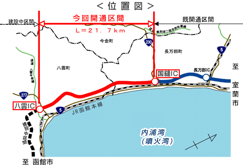
今回の開通する区間は、既に開通済みの国縫ICより南西(函館方向)へ進み、内浦湾(噴火湾)に面した海岸段丘に沿って、一般国道5号、JR函館本線と並行し、北海道二海郡八雲町立岩の八雲ICで一般国道277号に接続する延長21.7kmの区間です。
今回の開通により道央自動車道は道南に向けてさらに延伸されます。
- インターチェンジ(1箇所)
八雲IC 北海道二海郡八雲町立岩(一般国道277号と接続) - 車線数及び設計速度
1.車線数 2車線(暫定)
2.設計速度 100km毎時 - 工事概要
1.事業費 約328億円
2.構造物延長
土工延長 21.0km(97%)
橋梁延長 0.7km ( 3%)
2 開通の効果
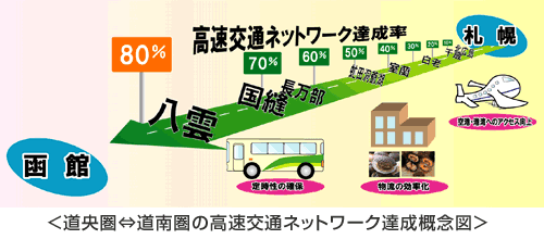
(1)ネットワーク達成率の向上今回の開通に伴い、道央圏から道南圏への高速交通ネットワーク達成率が8%向上し、全体の約80%が形成されます。
これにより、物流・輸送等の経済活動はもとより、地域間の交流促進や観光産業の活性化など、社会経済活動の発展に大きく寄与することが期待されます。
(2)災害時ネットワーク機能の強化
一般国道5号、周辺の幹線道路網との連携が強化されるとともに、国道277号と接続されることにより、災害時の代替道路等広域なネットワーク機能が強化されることにより、物流や緊急輸送路が確保され、沿線地域のライフラインとして重要な役割を果たすことができます。
(3)安心な暮らしの確保
今回開通する区間を利用することで、沿線町村から第二次救急医療施設(地域災害指定・八雲総合病院)までの搬送時間を、従来に比べ最大約6分短縮することができ、安心して暮らせる生活の確保と救急医療体制の構築に寄与することが期待されます。
3 工事の特色
- 走行する舗装表面(アスファルト表層工)部分には、より耐久性を高めて路面の状態を長期的に維持できる舗装を採用し、従来の舗装に比べて舗装修繕サイクルの長期化を図りました。
- 道路上に設置される防護さく(ガードレール)には、NEXCO東日本では初めて海外から安価な資材を直接調達し、従来の調達方法と比べて建設コストの削減を図りました。
関連サイト・コンテンツ
料金・ルート検索、サービスエリア・パーキングエリアの情報をお探しの方はこちら。
リアルタイムの渋滞・規制情報をお探しの方はこちら。
災害時の通行止めなどの道路情報をお探しの方はこちら。