[C3] Gaikan Expressway and [E17] Kan-Etsu Kan-Etsu Expressway Oizumi IC Night Lamp Closed
And Metropolitan Road No. 24 (Mejiro-dori) Notice of partial nighttime closure
July 6, 2020 (Thursday) From 21:00 to 5:00 the next morning
- Bridge construction work for the Tokyo Outer Ring Road will be carried out -
- Corporate Top
- Press Room
- Press Release Kanto Regional Head Office
- [C3] Gaikan Expressway and [E17] Kan-Etsu Kan-Etsu Expressway Oizumi IC Night Lamp Closure and Metropolitan Route 24 (Mejiro-dori) Notice of Partial Nighttime Closure
The latest regulatory information isDraTraPlease see.
June 6, 5th year of Reiwa
East Nippon Expressway Co., Ltd.
Tokyo outer ring construction office
NEXCO EAST At the Tokyo Gaikan Construction Office (Nerima-ku, Tokyo), C3 Gaikan Expressway (hereinafter referred to as "Gaikan Road") Oizumi Interchange (hereinafter referred to as "IC") In order to erect bridges in the vicinity, the C3 outer ring road and E17 Kan-Etsu Expressway (hereinafter referred to as "Kan-Etsu Expressway In addition, a section of the Metropolitan Route 24 Nerima Tokorozawa Line (hereinafter referred to as "Mejiro-dori") will also be closed to traffic.
Due to the closure of the ramp and the closure of the road, there is a risk of congestion on the detour of the general road, so please check the road information when you go out and use it with plenty of time.
We apologize for any inconvenience this may cause to customers using the Expressway, people living along the road, and everyone using Mejiro Street, and ask for your understanding and cooperation.
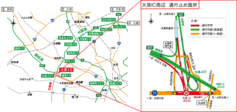
1. 1. Closing location and date and time
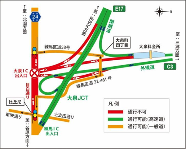
- Closed place:
- Outer ring road inner loop (from Wako direction) Oizumi IC exit ramp
- Outer ring road (towards Wako) Oizumi IC entrance ramp
- Kan-Etsu Expressway Out-bound Line (towards Tokorozawa) Oizumi IC entrance ramp
- About 0.4km around Mejiro-dori Oizumi IC
- Attached to each line C3 The indications such as indicate the route number (numbering) of Expressway.
- Date and time
Implementation date:July 6, 2020 (Thursday)21:00 pm-5 pm the next morningPreparation day:July 10th (Monday) to 13th (Thursday), 2023Every day from 21:00 to 5am the next morning
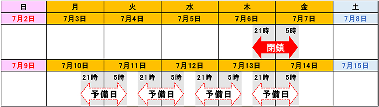

- In stormy weather, it will be postponed to the spare day.
- We will inform you of the implementation decision on Twitter etc. around 17:00 on the day.
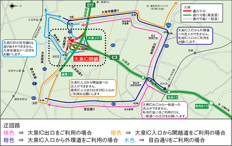
2. Detour
Please refer to the figure below for the detour.
The detour will take longer, so please leave plenty of time.
Customers using Expressway
- Customers traveling on the outer ring road (inner loop) and using the Oizumi IC exit will flow out at the Wako IC, as indicated by the pink arrow, and use "Sasame-dori" or "Oizumigakuen-dori" to reach "Mejiro". Please take a detour to the street. In addition, it is possible to pass to the direction of Kan-Etsu Expressway (Out-bound line).
- Customers using the outer ring road (outer loop) from the Oizumi IC entrance, please use "Sasame-dori" or "Oizumigakuen-dori" as indicated by the dark blue arrow, and enter from the Wako IC.
- Customers using the Kanetsu Kan-Etsu Expressway (Out-bound line) direction from the Oizumi IC entrance, please use Kan-Etsu Expressway Nerima IC or Tokorozawa IC as indicated by the orange arrow.
People using Mejiro-dori
- If you are using Mejiro-dori from the direction of Kitazono to the direction of Yahara, please use Route 32-461 from Nerima main district road No. 58 to take a detour.
- If you are using Mejiro-dori from Yahara to Kitazono, please use "Toei-dori", "Oizumi-kaido", and "Oizumi-gakuen-dori" to detour.
Detour diagram
Large view
[Reference: Required detour time]
<From Wako IC to Kitazono intersection>: Wako IC ⇒ Kawagoe Kaido ⇒ Oizumi Gakuen Dori ⇒ Kitazono intersection
Time required: about 20 minutes (approximately 15 minutes longer than when driving Expressway)
<From Wako IC to Yahara intersection>: Wako IC ⇒ Kawagoe Kaido ⇒ Sasame Dori ⇒ Yahara intersection
Time required: about 20 minutes (approximately 15 minutes longer than when driving Expressway)
<From Kitazono intersection to Nerima IC>: Kitazono intersection ⇒ Nerima main district road No. 58 ⇒ Nerima general district road No. 32-461 ⇒ Mejiro-dori ⇒ Sasame-dori ⇒ Kitahara-dori ⇒ Nerima IC
Time required about 16 minutes
<From Kitazono Intersection to Tokorozawa IC>: Kitazono Intersection ⇒ Oizumigakuen Dori ⇒ Kawagoe Highway ⇒ Urawa Tokorozawa Bypass ⇒ Tokorozawa IC
Time required about 32 minutes
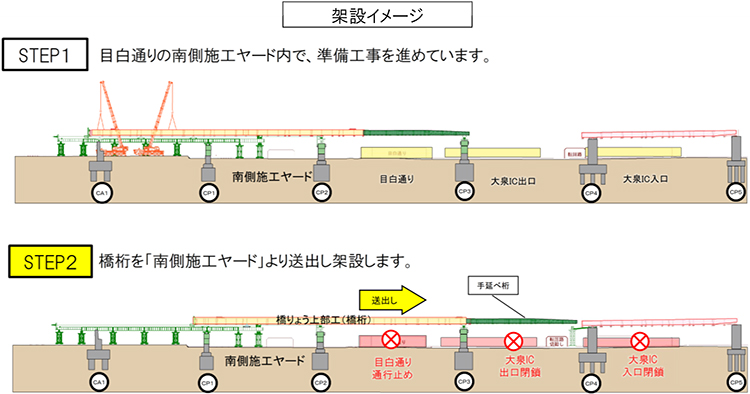
3. Construction overview
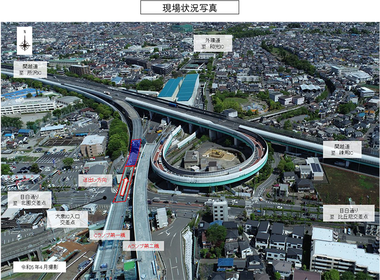
Along with the construction of the Tokyo Outer Ring Road (Kanetsu-Tomei), we will carry out the construction of a bridge that crosses over Mejiro-dori. In this construction, the bridge girders assembled in advance in the construction site work area will be moved to the piers by passing over Mejiro-dori using a delivery device (hydraulic jack).
Since this construction will pass over Mejiro Dori and near the Oizumi Interchange with heavy traffic, these roads will be closed during construction in consideration of safety. Therefore, in order to minimize inconvenience to customers, we will carry out construction work intensively and efficiently at night on weekdays when there is little traffic. We ask for your understanding and cooperation.
In addition, we plan to close the road in the same manner in the future. Details will be announced later.
Four. How to obtain traffic information
(1) Guidance by distribution / posting
- Notice signs, posters and leaflets will be posted at toll booths and rest facilities nearby.
- Post banners on overpasses on Expressway and pedestrian bridges on ordinary roads.
(2) Road traffic information that can be obtained before going out
- NEXCO東日本お客さまセンター(24時間オペレーターが対応)
ナビダイヤル:0570-024-024
または:03-5308-2424 - NEXCO EAST Expressway Traffic Information Site "DraTra"Real-time information[Mobile] http://m.drivetraffic.jp/Construction regulation information
- 日本道路交通情報センター(JARTIC) 道路交通情報
全国共通ダイヤル 050-3369-6666
(携帯電話短縮ダイヤル #8011)
※全国どこからでも最寄りの情報センターに接続します。
全国・関東甲信越情報 050-3369-6600
都内情報 050-3369-6613
【PC】https://www.jartic.or.jp/
(3) Road traffic information available while using the Expressway
- Road information board
- Highway radio (AM1620kHz)
The highway radio section is indicated by signs on the Expressway. - Highway Information Terminal
We will inform you of road information in an easy-to-understand manner by the monitor screens installed in SA / PA. - VICS
You can get road traffic information with VICS-compatible car navigation and other on-board devices.
- Information is also distributed on the official accounts of Twitter and LINE.
[Twitter]
"NEXCO EAST (Kanto)" (@e_nexco_kanto) real-time traffic information
"NEXCO EAST (Kanto Construction Regulations)" (@e_nexco_kanto_k) Decision to implement construction regulations
[LINE]
"NEXCO EAST" (@e-nexco) Road closures and weather information

To view the PDF file, you need the Adobe Systems plug-in software "Acrobat Reader (Japanese version)". If you do not have Download from here (free)Please use it.
Related Sites and Content
If you are looking for information on fares, routes, service areas and parking areas, please click here.
If you are looking for real-time traffic congestion and restriction information, click here.
NEXCO EAST (Road Disaster Prevention Information) Official X
Click here if you are looking for road information such as road closures during disasters.